Westman Islands: the volcano islands
In recent years, the world’s attention has been focused on Iceland’s Reykjanes peninsula. After being dormant for more than 800 years, a series of earthquake swarms in 2021 were the precursor to volcanic activity that has periodically made the headlines ever since. As fountains of lava spew high into the air and massive clouds of ash rise from newly formed craters, the spectacle they create reminds us of the majesty of nature and the awesome power of our constantly evolving planet. Most watch from afar, fascinated by the events that change the landscape so dramatically. Yet it’s by no means unprecedented.
For the residents of the Westman Islands, such change is an all too familiar story. In 1973, a similarly sudden volcanic eruption impacted those who lived here and the consequences were both devastating and long-lasting. Sitting on an active tectonic fault line, volcanic activity is to be expected – here’s the story of the Westman Islands: the volcano islands.
The creation of Eldfell
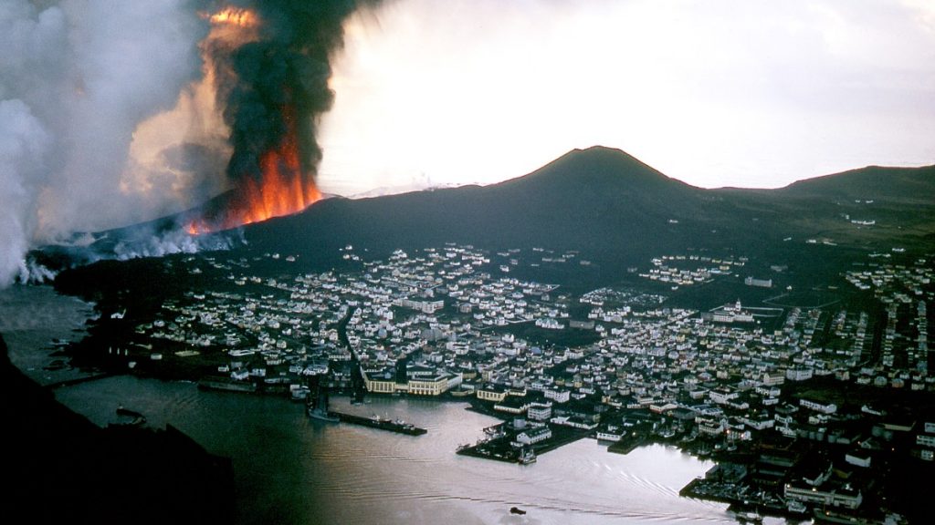
Let’s start with the Westman Island’s most famous eruption, the one that affected Heimaey in such a big way five decades ago. It came as a total shock; there had been no volcanic activity on Heimaey for thousands of years. There was almost zero warning prior to a mile-long fissure opening up on January 23rd 1973. From it spewed ash, magma, rocks and gases; it must have been a fearsome sight. For an island-based population, the reality of a volcano suddenly springing into action must have been a terrifying thought. But, in fact, the timing couldn’t have been better.
As is often the case in winter, a bad storm had rolled in. The Westman Islands had a sizeable fishing fleet, but because of the terrible weather, the boats hadn’t been able to go out into the open ocean as it was too rough and so they were still in the harbour. When the emergency evacuation order was announced, those same boats were put to work ferrying the island’s residents over to the mainland. Incredibly, given that this occurred in the early hours of the morning, within less than an hour the majority of the islanders were safely out of harm’s way.
About 200 people remained on the island to tackle another urgent problem. The lava flows that streamed from the earth threatened to engulf the harbour. If that happened, the livelihoods of the island’s fishermen would be threatened. Even if their boats were safely elsewhere, there’d be nowhere to moor up and unload the catch when they returned from sea. A plan was hastily put into action. Using 6.2 million tonnes of seawater from the harbour, these brave volunteers would spray the lava. The hope was that it would cool sufficiently and stop before it emptied into the harbour.
On land, barriers were constructed in a vain attempt to stop the lava swallowing up people’s homes. Sadly, they were no match for nature and around 400 properties were lost to the volcano. Today, one has been excavated as a visual reminder of those devastating events. When you stand in front of it, or hike up to the top of Eldfell – the volcanic cone that was created – it’s mind-blowing to think that only one person lost their life, a rescuer who inhaled deadly gases while at work.
The eruption lasted for five months, finally coming to an end on July 3rd. Many of the resilient islanders returned, picking up their lives where they left off. While some stayed away, for those who came back it was because Heimaey was their home, even though they were aware that there could be another eruption in the future. Today, monitoring systems and technology are the best they have ever been.

A new island: Surtsey
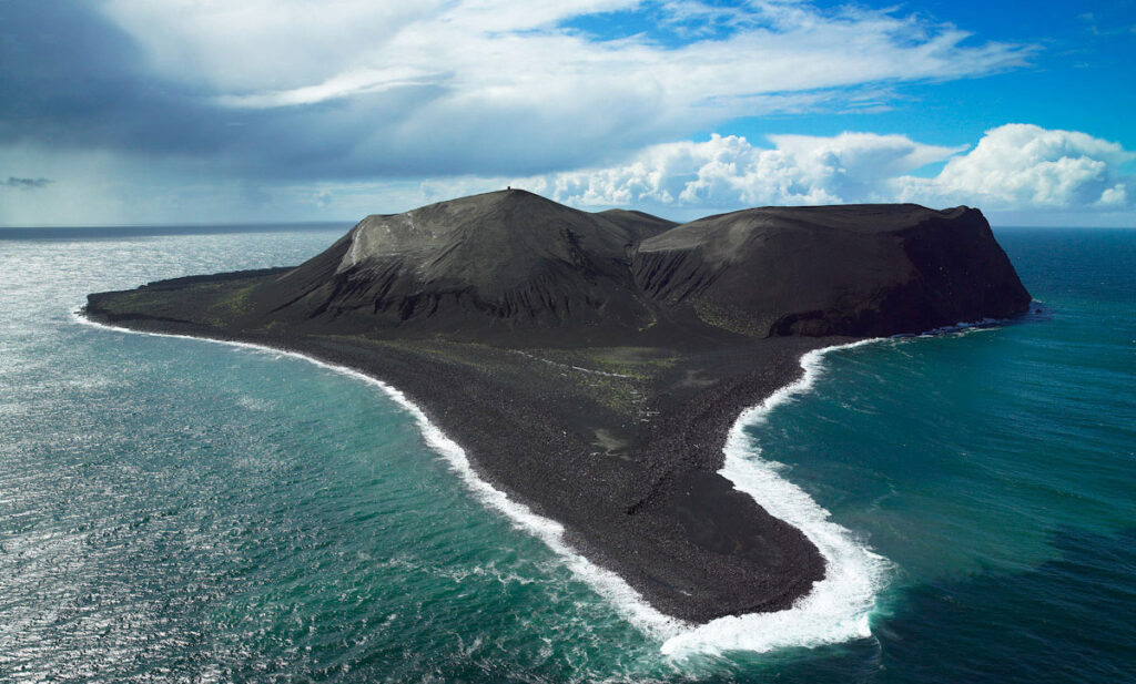
Eldfell wasn’t the only landform to have reshaped the landscape. Just ten years earlier, a brand new island began to take shape. Magma flowed up from the ocean floor. Between November 14th 1963 and June 5th 1967, continued flows of molten rock built up until the resulting landmass reached such a size that it appeared above the surface.
This new landform was given a name in 1965. The Icelanders named it Surtsey, after Surtur, who according to Norse mythology was the god of fire. Eventually, the island reached a considerable size. The highest point for a time was 171 metres above sea level, although erosion had brought that down to 154 metres when it was measured in 2008. Similarly, the island’s area was reduced a little; at the same time the area was 1.4 km2.
Unlike Eldfell, it isn’t possible to stand on Surtsey. It was agreed that this new piece of land would be an invaluable tool in scientific research into land colonisation, ecological succession and vegetation change. Right from the get-go, scientists have monitored the island as a pristine environment. They’ve recorded the progress of seeds that were washed here by the sea and they have tracked the development of mould, fungi and bacteria. Some have counted the number of plant species and studied how such plants have thrived. Others have focused on the birds that have settled here to nest and breed.
As a consequence, since 2008 the place has been designated a UNESCO World Heritage Site. While visitors are allowed to admire the island from the water, it’s not permitted to go ashore to ensure the integrity of future scientific data won’t be impacted.

So why are the Westman Islands prone to volcanic activity?
The incidence of volcanic activity in the Westman Islands is no accident. Geologically the islands are very young, perhaps as little as 10000 years old. Of course, Iceland itself sits on the Mid-Atlantic Ridge. Where the North American and Eurasian tectonic plates are pulling slowly apart, magma is able to find a way to the surface. It’s this process that has led to the formation of new land as happened with Surtsey.
Heimaey is the result of several eruptions. Geologists have concluded that different parts of the island have been formed at different times. For example, Norðurklettar (the northern cliffs) are thought to be at least 10000 years old and most likely sprang up during an eruption that took place in the last Ice Age. About 6000 years ago, a separate eruption created what was then a third island, Stórhöfði, now the southern part of Heimaey.
A millennium later, another explosive eruption began, this time at Stakkabótagígur. This caused Stórhöfði to grow larger. Some volcanic craters formed, but the most significant event during this period was the eruption of Helgafell. Lava flowed from this crater near what’s now the main town and closed the gap, linking the island with Stórhöfði as a gravel isthmus formed.
Therefore in this context, we can see that those 20th century eruptions simply form part of a much longer process. It’s not much of a stretch to realise that the future will bring more change. Tectonic activity together with erosion and deposition by the sea will continue to shape the Westman Islands. The visitors of the future will look back at the events that created first Surtsey and then Eldfell as part of a much longer episode in Vestmannaeyjar’s history. While you visit the Westman Islands, you can explore this volcanic landscape on an ATV tour. Why not take a look at our website and find out more?